


IRISHTOWN 2 Voting District, Clinton County, Illinois
About
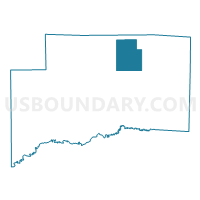
Outline

Summary
| Unique Area Identifier | 564945 |
| Name | IRISHTOWN 2 Voting District |
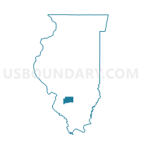
| County | Clinton County |
| State | Illinois |
| Area (square miles) | 20.87 |
| Land Area (square miles) | 18.10 |
| Water Area (square miles) | 2.77 |
| % of Land Area | 86.71 |
| % of Water Area | 13.29 |
| Latitude of the Internal Point | 38.69070110 |
| Longtitude of the Internal Point | -89.33308530 |
Maps

Graphs
Select a template below for downloading or customizing gragh for IRISHTOWN 2 Voting District, Clinton County, Illinois


Neighbors
Neighoring Voting District (by Name) Neighboring Voting District on the Map
- CARLYLE 2 Voting District, Clinton County, IL
- CLEMENT Voting District, Clinton County, IL
- IRISHTOWN 1 Voting District, Clinton County, IL
- WHEATFIELD Voting District, Clinton County, IL
Top 10 Neighboring County Subdivision (by Population) Neighboring County Subdivision on the Map
- Carlyle township, Clinton County, IL (3,932)
- Irishtown township, Clinton County, IL (1,167)
- Wheatfield township, Clinton County, IL (478)
- Clement township, Clinton County, IL (475)